| |
This is a two-ended backcountry hiking trail with two trailheads, so if you can get a ride from someone, you can hike it just one way. This hiking trail sometimes gets very dry, so make sure you check current conditions and fire restrictions with local forest authorities before you head out. The total elevation difference for Mount Ashland Trail is 2,165 feet, and that is about average. The time needed for this backcountry hike is roughly 6 hours, but you never know stuff could go wrong and you could get stuck so be prepared for that. Some parts of this hiking trail are much higher up than other parts of the hiking trail, so keep in mind that you may need to dress differently at different elevations. With its 6.8 miles of walking distance it's an average length hiking trail. This is a hiking trail that is quite long, so do pack enough food to last the whole trip.
|
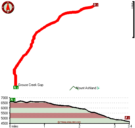
Trailhead 1 to Trailhead 2:
Total hiking length = 3.4 miles
Total climbing distance = .3 miles
Difficulty : Easy
Casual Hiking Pace:
2.5 hours
Fast Hiking Pace:
1 hours
Trailhead 2 to Trailhead 1:
Total hiking length = 3.4 miles
Total climbing distance = 2.4 miles
Difficulty : Difficult
Casual Hiking Pace:
3.5 hours
Fast Hiking Pace:
2 hours
| | Trailhead 1 back to Trailhead 1:
Total hiking length = 6.8 miles
Total climbing distance = 2.7 miles
Difficulty : Difficult
Casual Hiking Pace:
6 hours
Fast Hiking Pace:
4 hours
Trailhead 2 back to Trailhead 2:
Total hiking length = 6.8 miles
Total climbing distance = 2.7 miles
Difficulty : Difficult
Casual Hiking Pace:
6 hours
Fast Hiking Pace:
4 hours
|
Total elevation difference: 2165 feet
|


